|
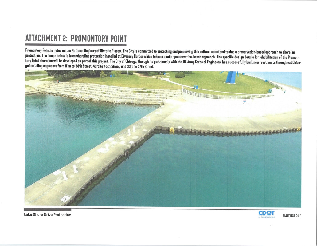
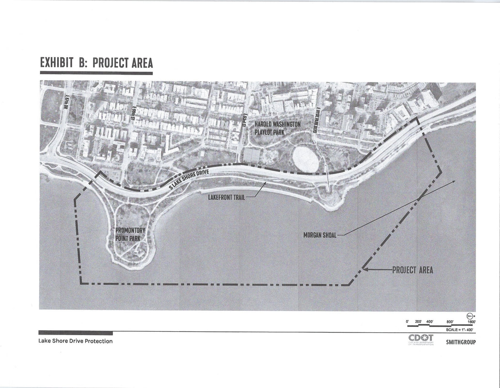
First, it's very important to know that the "locally preferred plan" is NOT the plan locally preferred by the community. As it currently stands, the “locally preferred plan” is demolition of the limestone revetment and new construction of textured concrete with decorative and ornamental limestone blocks in the parkland. This is what the City (CDOT) and the Chicago Park District (CPD) call the "locally preferred plan" and what they currently plan for the Point. We know that's what CDOT and CPD are planning from public information. First, on CDOT’s Shoreline Protection Project webpage, CDOT clearly states what the “locally preferred plan” is and what they mean by preservation: “The preferred design of the revetment is vertical steel sheet piles to replace the damaged wood piles, and concrete steps and promenade to replace the existing stones. This design maintains safe access to the shoreline while preserving its historical and aesthetic value.” (Promontory Point and Morgan Shoal are listed as "Reach 4-step stone revetment reconstruction from 23rd Street to 57th Street alongside Lake Shore Drive” on the same webpage.) Also, through FOIA, the Conservancy obtained CDOT's BRIC FEMA Pre-application, dated September 30, 2020. On page four of the exhibits, CDOT clearly specifies exactly what it means by "a preservation based approach" at Promontory Point: a new revetment of textured concrete with decorative limestone blocks in the parkland. CDOT engineers confirmed the "locally preferred plan" as recently as October 18, 2022 when the Conservancy walked the Point with CPD and CDOT commissioners and senior staff. In the exhibit pages below excerpted from the BRIC FEMA Pre-application, CDOT and SmithGroup (CPD's favored engineering/planning firm) layout the emergency storm erosion crisis project area and illustrate what the "locally preferred plan" looks like for Promontory Point. As you can see, Promontory Point -- where there is no storm damage erosion crisis and no threat to private property, DuSable Lakeshore Drive or human life -- is falsely bundled with Morgan Shoal as one emergency reach. And the color illustration spells out a purported "preservation based approach" of demolition of the historic limestone revetment and replacement with a concrete revetment. Here, like at 57th Street Beach's concrete revetment, limestone blocks are placed in the nearby parkland for decorative and ornamental purposes and do not function as the revetment. Illustration above: CDOT and SmithGroup's caption reads: "Promontory Point is listed on the National Registry of Historic Places. The City is committed to protecting and preserving this cultural asset and taking a preservation-based approach to shoreline protection. The image below is from shoreline protection installed at Diversey Harbor which takes a similar preservation-based approach. The specific design details for rehabilitation of Promontory Point shoreline will be developed as part of [the Morgan Shoal Project]. The City of Chicago, through its partnership with the US Army Corps of Engineers, has successfully built new revetments throughout Chicago including segments from 51st to 54th Street, 43rd to 45th Street, and 33rd to 37th Street." Obviously, the Conservancy, other preservationists and qualified marine engineering firms with preservation experience disagree with this assessment entirely. Map above: Bundling Promontory Point in a single reach with Morgan Shoal and calling it one project allow CDOT and SmithGroup (CPD) to inflate and exaggerate erosion, storm damage conditions at Promontory Point. CDOT and CPD lump Promontory Point into the second phase of work of the Morgan Shoal Project. Construction has already been awarded to SmithGroup and its partners to begin construction at Morgan Shoal. It's not clear whether that contract includes Promontory Point too in the scope of work. Right now, the City and CPD are fully funded for construction of the current "locally preferred plan" of demolition and a new concrete revetment at Promontory Point and Morgan Shoal. On December 15, 2022, the City won 65% federal funding for its "locally preferred plan". With the passage of the Defense appropriations by Congress, the City and CPD received federal funding appropriation to construct the "locally preferred plan": 65% funding for demolition and a new concrete revetment funnels through the Chicago Army Corps, and the City will pay 35% through its November 2020 General Bond Obligation offering which specifically names Morgan Shoal and Promontory Point as capital projects. The Army Corps, the Mayor's Office and CPD snuck this huge federal appropriation in without informing U.S. Congresswoman Robin Kelly in whose district the Point sits and who has persistently requested federal funds for preservation at the Point and without informing Alderman Leslie Hairston.
Based on circumstancial evidence and the agencies' ongoing obfuscations, the Conservancy believes that the Corps, the City and CPD are using the current General Reevaluation Study (GRR) of the Chicago lakefront, including Promontory Point, to back into CPD's SmithGroup study for demolition and a new concrete revetment at the Point. As confirmed by CPD last June, SmithGroup has completed Phase I (condition/assessment study) and Phase II (design/strategic action plan) for Promontory Point. CPD has refused to release these findings to the press, to elected representatives and to the Conservancy. Neither SmithGroup nor the Chicago Corps has any relevant preservation expertise to make a legitimate plan for a preservation approach at Promontory Point. The terminology "locally preferred plan" comes from the U.S. Army Corps of Engineers which must distinquish between its plan (cheap rubble mound) and the plan preferred by its local clients, CPD and CDOT. Hence, the "locally preferred plan". If the CPD and CDOT were sincere about preservation and listening to the wishes of the community, a genuine preservation approach -- such as the Conservancy's preservation marine engineering studies -- could be adopted by the agencies as the "locally preferred plan". To date, neither the Mayor's Office, CPD, CDOT nor the Corps has supported genuine preservation -- repair and restoration -- at the Point.
0 Comments
Thanks to your 600 letters, the Commission on Chicago Landmarks granted preliminary landmark recommendation for Promontory Point during its meeting on January 12th.
Multiple commissioners, Alderman Hairston, Alderman Garza, Chicago parks historian Julia Bacharach, and other speakers mentioned the enthusiasm and passion for preservation that was evident through the hundreds of letters they received from Point lovers. You're the point. But we're not done yet! Next, the City Council Committee on Zoning, Landmarks and Building Standards will vote to recommend the designation to the full city council. Read the letters of support from Point lovers here. Watch the video of the meeting. Art on the revetment: Bill Swislow comments to the Corps about this historic asset on the lakefront1/9/2023 Dear Ms. Belcik, Chicago Command, U.S. Army Corps of Engineers
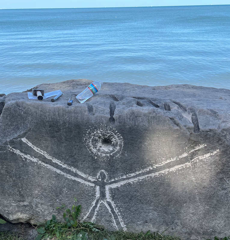
Please accept this comment for the NEPA review of the Chicago Coastal Storm Risk Management study. The historical limestone revetments and related structures at Morgan Shoal, Promontory Point and La Rabida have done more than protect the Chicago shoreline from erosion and flooding. They also have served as a canvas for thousands of mostly anonymous Chicagoans who have carved portraits and other images, names, messages and more into the rocks for almost a century. I have spent the last few decades documenting the carvings on the revetments all along the Chicago shoreline, researching their history, tracking down and interviewing carvers, conducting walking tours (including at Promontory Point), doing numerous public presentations on the carvings, and, in 2021, publishing a book on the subject (Lakefront Anonymous: Chicago’s Unknown Art Gallery). Effectively, the carvings on these rocks represent a spontaneous social history of Chicago’s life along the lake as well as combining to form a collective work of art that has gone largely unrecognized but is striking once you start noticing the thousands of carvings lining the shore. These urban petroglyphs start near the Indiana state line and continue north to Osterman Beach at Hollywood Avenue. I have photographed the more than 6,000 that survive; thousands more were destroyed during the Corps’ shoreline protection work in the first two decades of the 2000s, from north of Promontory Point to Montrose Harbor. Although several hundred rocks from the old revetments were saved, and thus a smattering of the carvings in those locations, most of the thousands of blocks and the artwork on them were lost. That cavalier treatment, which I believe was partly based on general ignorance of the carvings’ existence and importance, must not be repeated. This aggregation of modern rock carvings concentrated along a major urban shoreline is, based on my research, not duplicated anywhere else in the world. And Morgan Shoal, Promontory Point and La Rabida are major contributors to this unique resource. They each host significant surviving concentrations of carvings – more than 1,000 along Morgan Shoal, close to 600 at La Rabida and more than 500 lining Promontory Point. The Morgan Shoal carvings include the oldest ones documented, the first of them dated June 1930, as well as several figurative and typographical carvings of significant artistic merit. Behind La Rabida Hospital there is an exceptionally dense concentration of carvings, some of them rich with historical references. There is also a line of rocks bearing carvings on an old revetment/breakwater that now sits about 10 feet offshore south of La Rabida. And at Promontory Point are some of the most whimsical historical carvings as well as some of the newest, with more than 20 executed this year added to the hundreds already there dating to back to the 1930s. All these carvings are at risk from any shoreline protection plan that does not include preservation of the historical limestone. And all are at continuing risk from storm and erosion damage. At all three locations important carvings have either already fallen into the lake along with their host rocks or are in the process of falling. So while it is important for the future of this art that shoreline rehabilitation proceed, it’s only hope of survival is that any rehabilitation retains as many of the limestone blocks as feasible, preferably in place, as opposed to sending them to the crusher or other dismal fates. Retention of the limestone means different things at each location. Much of the revetment at Morgan Shoal is so decayed as to make preservation in place unworkable, so the best hope is that rocks bearing impactful carvings are identified and repurposed for seating or ornamental use. This was done to a limited extent along the Belmont Rocks north of Diversey Avenue, and to better effect at Fullerton Avenue, where the carvings were treated as an important feature worth saving and keeping visible in new configurations. Similarly, a number of blocks were saved in the Oakwood Beach vicinity and reused as seating and ornamental elements. At Morgan Shoal, in addition to the revetment features, there are rocks essentially installed as large paving stones adjacent to the 49th Street Beach House, flush with the ground and heavily carved. These also should be preserved in some form, either in place or nearby. The rocks behind La Rabida hospital have suffered greatly in the last five years. Those nearest the lake are tumbling into the water (including one that hosts one of the finest of the lakefront carvings, a fully executed compass) and the rest show the ill effects of weather-driven shifts in the rocks. These rocks could be stabilized in place or repurposed nearby, as long as efforts necessary to preserve the carvings are undertaken. Similarly, the line of offshore rocks south of La Rabida should be surveyed for carvings and either preserved in place or relocated nearby. These rocks include one bearing one of the most unusual, masterful and historically interesting group of carvings to be found along the lake, made apparently by one hand between 1948 and 1953. Of the three sites, Promontory Point is the one where the carvings, and the rocks that host them, can nearly all be preserved in place, per the plans formulated by the Promontory Point Conservancy. This allows the art to be seen as it was experienced and left by the artists and their friends over the decades since the Point was constructed in the 1930s. The carvings generally add to the historical character of the limestone revetments while also lining the Point with social history and artwork of substantial merit. In all locations, for the carvings to be preserved, whether in place or nearby, their presence needs to be recognized and taken into account in the construction planning. This means inventorying the carvings, identifying the ones with sufficient merit to be preserved, and then taking great care when moving, resetting, or otherwise modifying their position. Even when efforts are made to save rocks with carvings, the process of moving them off their current location can result in their unintentional destruction, per the landscape architect on the Fullerton Avenue project. In addition, consideration of artistic merit needs to look beyond individual carvings to account for their impact in totality. While not every last carving may be worth preserving, some carvings grouped together become more than the sum of the parts. Images and more information on the carvings are available at lakefrontanonymous.com and in my Lakefront Anonymous book – the first full-length study of the carvings, including their history as well as more than 200 images. Thanks for the opportunity to comment on this important project. William Swislow [email protected] |
Categories
All
Archives
July 2024
AuthorDebra Hammond is currently an officer of Promontory Point Conservancy. She has always been tall for her age |


